Landslide Potential Zone Identification Using Electrical Resistivity Tomography Modeling
Abstract
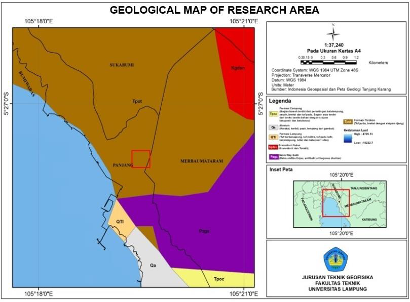
The Pidada area, Panjang sub-district, Bandar Lampung City, is located on the physiography of Bukit Barisan and is also influenced by the movement of the Sumatran fault and the Lampung-Panjang fault, so the morphological condition is hilly with steep slopes which cause natural disasters such as landslides. In this study, the knowledge of subsurface rock lithology and slip-slide-prone zones was carried out using the Wenner-Schlumberger geoelectric method. Based on the Wenner-Schlumberger configuration, the top layer consists of weathered rock associated with clay tuff and sandy tuff with a resistivity of 7.2 ?m - 135 ?m. Coarse-grained tuff and fine-grained tuff with resistivity values ??of 135 ?m - 437 ?m, and the third layer combines breccia and igneous rock from the Tarahan Formation with resistivity values ??of more than 437 ?m. The clay sand layer acts as a slip plane. The type of landslide developed in the research area is a crawling soil landslide.
Downloads
References
A. Zamroni, A. C. Kurniati, and H. N. E. Prasetya, “The assessment of landslides disaster mitigation in Java Island, Indonesia: a review,” Journal of Geoscience, Engineering, Environment, and Technology, vol. 5, no. 3, pp. 139–144, 2020, doi: 10.25299/jgeet.2020.5.3.4676.
C. N. Poland and P. Zientara, “Advancing Culture of Living with Landslides,” Advancing Culture of Living with Landslides, 2017, doi: 10.1007/978-3-319-53487-9.
Y. Kumoro, H. Z. Anwar, Comaluddin, Yunarto, W. H. Nur, and Sukaca, “Potensi Kebencanaan Geologi dan Kerentanan Sosial sebagai dasar Penyusunan Tata Ruang di Kabupaten Tanggamus Propinsi Lampung,” Peran Puslit Geoteknologi dalam Optimalisasi Pemanfaatan Sumberdaya Alam dan Mitigasi Kebencanaan di Indonesia, pp. 107–122, 2009.
S. A. Mangga, Amirudin, T. Suwarti, S. Gafoer, and Sidarta, “Peta Geologi Lembar Tanjungkarang, Sumatera, skala 1:250.000,” 1993.
W. M. Telford, L. P. Geldart, and R. E. Sheriff, Applied Geophysics: Second Edition. Cambridge University Press, 1990.
R. A. van Zuidam and F. I. van Zuidam-Cancelado, Terrain Analysis and Classification Using Aerial Photographs: A Geomorphological Approach. in ITC textbook of photo-interpretation. International Institute for Aerial Survey and Earth Sciences, 1979. [Online]. Available: https://books.google.co.id/books?id=krziHAAACAAJ
W. R. Pratama, “Aplikasi Metode Geolistrik Resistivitas Konfigurasi Wenner- Schlumberger Untuk Mengidentifikasi Litologi Batuan Bawah Permukaan dan Fluida Panas Bumi Way Ratai di Area Manifestasi Padok di KEcamatan Padang Cermin Kabupaten Pesawaran Provinsi Lampung,” Jurnal Geofisika Eksplorasi, vol. 5, no. 1, pp. 30–44, 2019, doi: 10.23960/jge.v.
M. H. Loke, “Electrical Imaging Surveys for Environmental and Engineering Studies. A Practical Guide to 2-D and 3-D Surveys,” RES2DINV Manual, IRIS Instruments, 2001, [Online]. Available: www.iris-instruments.com
M. H. Loke and R. D. Barker, “Rapid least-squares inversion of apparent resistivity pseudosections by a quasi-Newton method,” Geophys Prospect, vol. 44, no. 1, pp. 131–152, 1996, doi: 10.1111/j.1365-2478.1996.tb00142.x.
R. C. Wibowo, B. S. Mulyatno, M. Romosi, and A. Zaenudin, “Determination of slip surface area using geoelectric, MASW, and soil mechanics data in cimuncang village, west Java,” in EAGE-HAGI 1st Asia Pacific Meeting on Near Surface Geoscience and Engineering, Yogyakarta, 2018, pp. 0–4. doi: 10.3997/2214-4609.201800360.
H. Grandis and Y. Maulana, “PEMODELAN INVERSI MAGNETOTELLURIK 1-D MENGGUNAKAN ALGORITMA PSO ( PARTICLE SWARM OPTIMIZATION ),” no. September, pp. 26–29, 2011.
Asriza, Supriyanto, T. H. W. Kristyanto, T. L. Indra, R. Syahputra, and A. S. Tempessy, “Determination of the Landslide Slip Surface Using Electrical Resistivity Tomography (ERT) Technique,” in 4th World Landslide Forum, Ljubljana, 2017. doi: 10.1007/978-3-319-53498-5.
I. Dost, R. Putiska, and D. Kusnirak, “Determination of shear surface of landslides using electrical resistivity tomography,” Contributions to Geophysics and Geodesy, vol. 44, pp. 133–147, 2014, doi: 10.2478/congeo-2014-0008.
R. Mulyasari et al., “Aplikasi Metode Geolistrik Resistivitas Untuk Analisis Bidang Gelincir Dan Studi Karakteristik Longsoran Di Jalan Raya Suban Bandar Lampung,” Jurnal Geofisika Eksplorasi, vol. 6, no. 1, pp. 66–76, 2020, doi: 10.23960/jge.v6i1.61.
R. Mulyasari, S. Suharno, N. Haerudin, H. Hesti, I. B. S. Yogi, and S. P. Saputro, “Aplikasi Metode Geolistrik dan Analisis X-Ray Diffraction (XRD) untuk Investigasi Longsor di Pidada, Kecamatan Panjang, Bandar Lampung,” Eksplorium, vol. 42, no. 2, p. 131, 2021, doi: 10.17146/eksplorium.2021.42.2.6304.
BPS, “Laju Pertumbuhan Penduduk Per Tahun 2018-2019 Kota Bandar Lampung,” Bandar Lampung, 2020.
P. O. Falae, D. P. Kanungo, P. K. S. Chauhan, and R. K. Dash, “Electrical resistivity tomography (ERT) based subsurface characterisation of Pakhi Landslide, Garhwal Himalayas, India,” Environ Earth Sci, vol. 78, no. 14, 2019, doi: 10.1007/s12665-019-8430-x.
D. Jongmans and S. Garambois, “Geophysical investigation of landslides?: a review,” Bulletin Société Géologique de France, vol. 178, no. 2, pp. 101–112, 2007, doi: 10.2113/gss- gfbull.178.2.101.