Volume Estimation Using Resistivity Tomography Method In Bakauheni, South Lampung
DOI:
https://doi.org/10.23960/jesr.v7i1.206 - Abstract View: 78Keywords:
Volume, Resistivity, Tomography, BakauheniAbstract
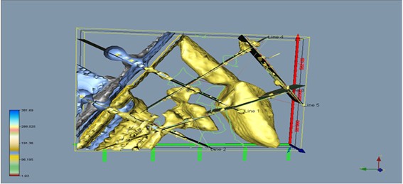
Lampung is an area that has various natural resources, one of which is andesite rock. National economic growth and incessant infrastructure development have resulted in an increased need for building materials, including Andesite. Andesite rocks are widely used for the formation of building foundations, making bridges, and paving roads. In this study, the volume of andesite rocks was calculated using the resistivity tomography method in the Bakauheni area of South Lampung in Pegantungan, Bakauheni District, South Lampung Regency, Lampung Province. which consists of 5 lines with a spacing between electrodes of 5 meters, with a span length of about 315 meters. The apparent resistivity data obtained are processed into a two-dimensional model through linear inversion using RES2DINV software. The two-dimensional model was then interpolated using the Rockworks 15 tool to become a three-dimensional model. Based on the 2D cross-section model, the high resistivity values varied. identified as andesite rock, which is imaged in red to purple colour, and volumetric andesite rock based on 3D interpolation for an area of ± 15.20 Ha is 3,411,066.876 m3.
Downloads
References
D. Mutebi, A. A. Nur, A. D. Haryanto, and J. Wiwid, “Variation of rock electrical resistivity in andesitic-trachytic volcanic geothermal areas. A case study of lili-sepporaki, Sulawesi Island-Indonesia,” Evergreen, vol. 7, no. 3, pp. 314–322, 2020, doi: 10.5109/4068609.
M. S. Sadewo, D. Muslim, and A. Soehaimi, “Studi Morfostruktur dan Paleoseismik Sesar Way Baka di daerah Bakauheni, Lampung Selatan,” Jurnal Lingkungan dan Bencana Geologi, vol. 4, no. 1, pp. 1–13, 2013.
R. C. Wibowo, I. Maulia, N. Haerudin, and M. Sarkowi, “Sliding Plane Identification for Landslide Hazard Mitigation with Electrical Resistivity Tomography Method,” Indonesian Physical Review, vol. 6, no. 1, pp. 1–10, 2023, doi: https://doi.org/10.2930 3/ipr.v6i1.181.
S. A. Mangga, Amirudin, T. Suwarti, S. Gafoer, and Sidarta, “Peta Geologi Lembar Tanjungkarang, Sumatera, skala 1:250.000,” 1993.
M. Sarkowi and R. C. Wibowo, “Geothermal Reservoir Identification based on Gravity Data Analysis in Rajabasa Area- Lampung,” RISET Geologi dan Pertambangan, vol. 31, no. 2, p. 77, 2021, doi: 10.14203/risetgeotam2021.v31.1164.
W. M. Telford, L. P. Geldart, and R. E. Sheriff, Applied Geophysics: Second Edition. Cambridge University Press, 1990.
M. H. Loke, “Electrical Imaging Surveys for Environmental and Engineering Studies. A Practical Guide to 2-D and 3-D Surveys,” RES2DINV Manual, IRIS Instruments, 2001, [Online]. Available: www.iris-instruments.com
Downloads
Published
How to Cite
Issue
Section
License
Copyright (c) 2025 Journal of Engineering and Scientific Research

This work is licensed under a Creative Commons Attribution 4.0 International License.