Comparison of DBSCAN Algorithm and Resistivity Data Inversion, Case Study of Identification of Granite Distribution in ‘Zs’ Area
DOI:
https://doi.org/10.23960/jesr.v7i1.168 - Abstract View: 85Abstract
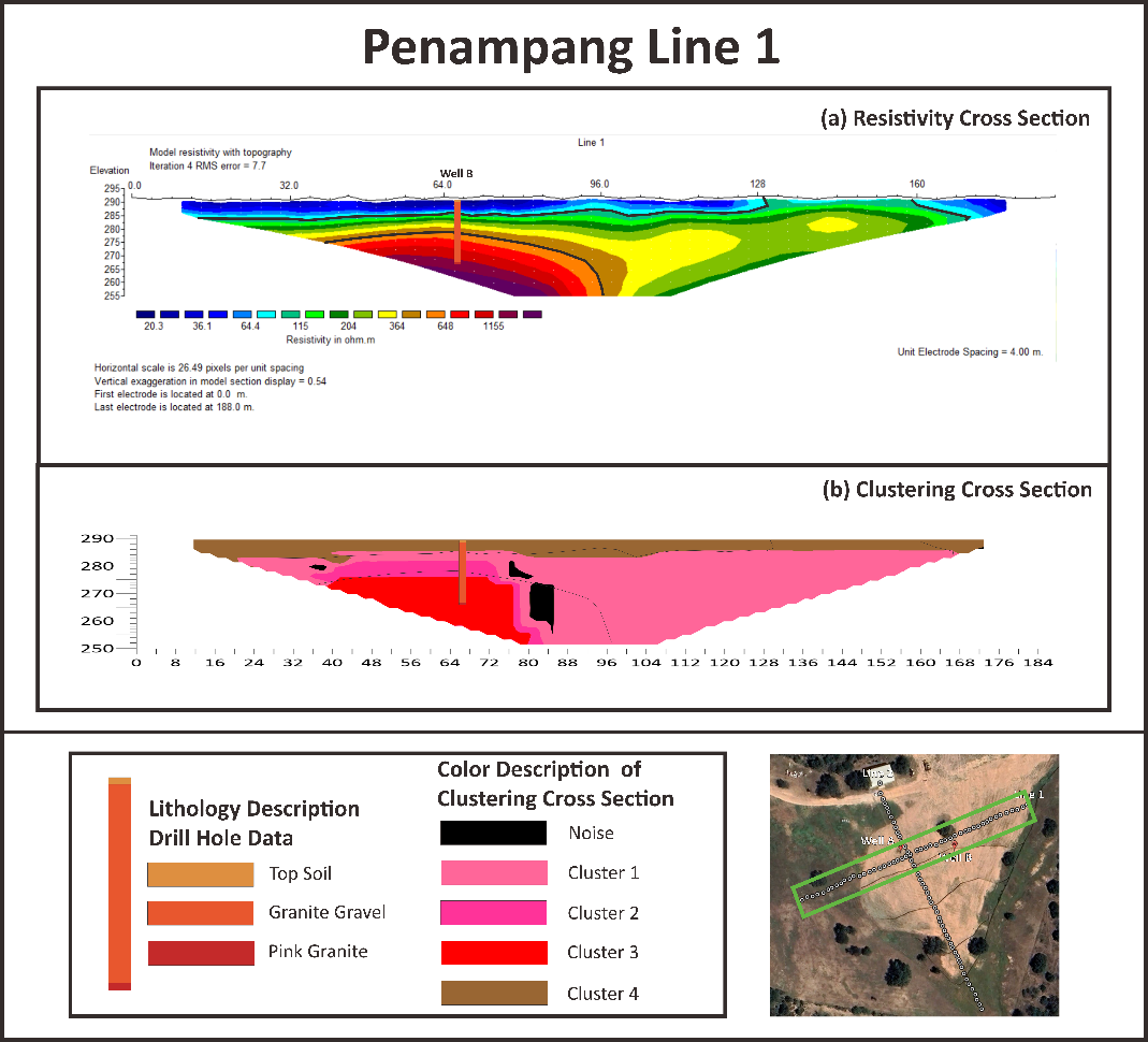
The emergence of automatic data analysis techniques based on data mining algorithms can be applied in various fields including geophysics, thereby improving the quality of interpretation results. Wanner-Schlumberger configuration resistivity data were used in this study. Geoelectric data processing usually uses inversion methods, to determine the true resistivity distribution below the surface. This study proposes the use of the DBSCAN algorithm. Inversion comparison with linearization and clustering with the DBSCAN algorithm is carried out to identify granite dispersal in the 'ZS' area. The clustered cross-section has a clearer picture than the inversion cross-section. Based on the interpretation results on the resistivity cross-section that has an RMS error value of 0.68%, three ranges of resistivity values can be interpreted, namely low resistivity values < 100 ohms.m are indicated as soil, medium resistivity values of 100 – 500 ohms.m are indicated as granite gravel aquifers, and resistivity values > 500 ohms.m are indicated as pink basement granite. The cross-section of clustering results with input parameters eps 0.22 and mints 7 is interpreted. Namely, cluster 1 is an unsaturated granite gravel aquifer, cluster 2 is a saturated granite gravel aquifer, cluster 3 pink granite bedrock, cluster 4 soil and noise of 5.54%Downloads
Download data is not yet available.
Downloads
Published
2025-06-22
How to Cite
[1]
Muhammad Azis Albar and Y. Yatini, “Comparison of DBSCAN Algorithm and Resistivity Data Inversion, Case Study of Identification of Granite Distribution in ‘Zs’ Area ”, JESR, vol. 7, no. 1, pp. 1–7, Jun. 2025.
Issue
Section
Articles
License
Copyright (c) 2025 Journal of Engineering and Scientific Research

This work is licensed under a Creative Commons Attribution 4.0 International License.